Due
to the Fact that the GeoCommunicator is no longer serving the Mining Claims
Data, this tutorial is no longer very useful. The best place to find out about
active mining claims in an area is by using the BLM's LR2000 database.
I've
got a tutorial for that too. So try this one:
Demystifying
the LR200
A
Quick Guide to Finding BLM Mining Claims with the MinerDiggins Gold Atlas
By
Ruby Miner
The
USGS provides an information website called the GeoCommunicator. This website
used to be a "One-Stop" shop for finding information about land status,
mining claims, grazing allotments and much more. This website has stopped providing
much of the information useful to prospectors, such as mining claims and land
status.
We
have created the - MinerDiggins Gold
Atlas to help fill the void left by these changes.
The Gold Atlas uses Google Earth to display data that can aid prospectors in
their search for Gold.
Download
a FREE copy HERE.
The
Gold Atlas is designed to help prospectors
with very broad searches and provides generalized information. It will link
you directly into the BLM LR2000 database. Please be reminded that the LR2000
claims data is only mapped to the Quarter Section, not to the actual Claims
boundaries. And also that the LR2000 is rarely current, and can be 3 to 6 months
behind on updates.
The
Mining Claims Map layers (active, closed, plans & notices, etc.) will no
longer be updated by the BLM. Be advised, they may stop providing these
layers at any time. We are working to find a way to continue providing this
information with the Gold Atlas.
There
are many map layers provided in the Gold
Atlas. In this tutorial I will focus on only those
required to access the BLM LR2000 functions.
This
tutorial provides a few simple steps to follow to find active mining claims
in a specific Township, Range and Section and access the LR2000 serial register
reports for these claims. There are many options available for you to try should
you desire additional information.
Some
basic rules for using Google Earth and the Gold Atlas:
Make
sure that your "Places Panel" is showing. Toggle
 on the tool bar to turn
it on.
on the tool bar to turn
it on.
Keep
the number of layers checked to a minimum.
Zoom
into an area of interest before turning on any new layers. Some layers
will not display until you are Zoomed in far enough.
Don't
check the box in front of a FOLDER. This may crash the program.
Learn
to use the Google Earth Tools. Go to Help and read the Users Guide.
Explore
and have fun looking down at your own backyard.
Follow
this simple Tutorial - Click by Click - to Access the BLM LR2000 records on
your favorite prospecting area.
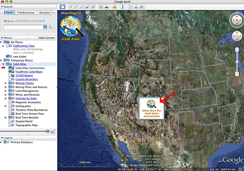
STEP
1:
Download and Open the
MinerDiggins Gold Atlas. Read the Instructions
by clicking on the center image and then turn it off by unclicking the checkbox
titled "Gold Atlas Instructions"
Download
a FREE copy HERE.
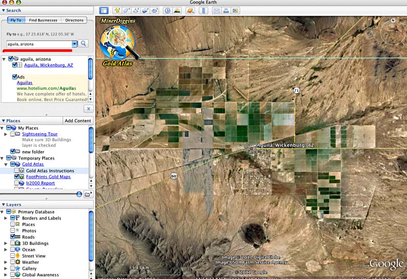
STEP
2:
Zoom to your Place of Interest by typing the name in the "Fly to"
block.
I
have chosen to use Aguila, Arizona.
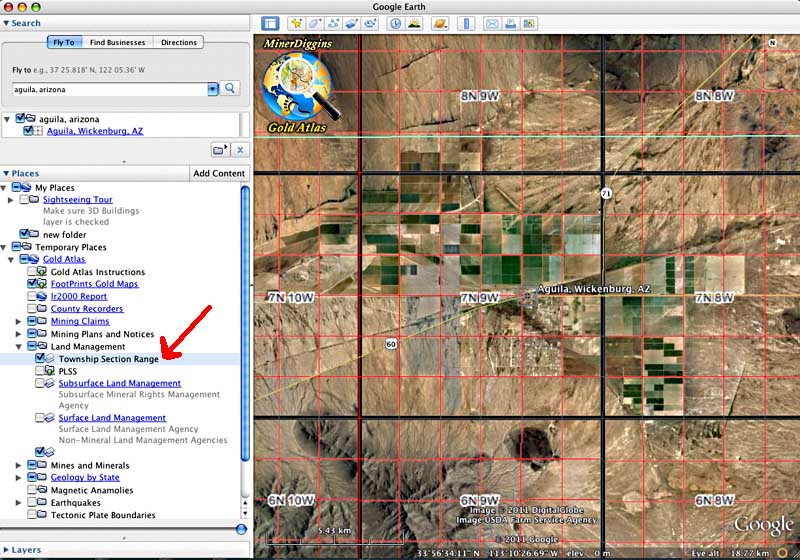
STEP
3:
Turn on the Township, Range and Section map layer. This will help limit your
search. Open the "Land Management" Folder and Check the layer titled
"Township, Range, Section".
This
will add a grid to your image.
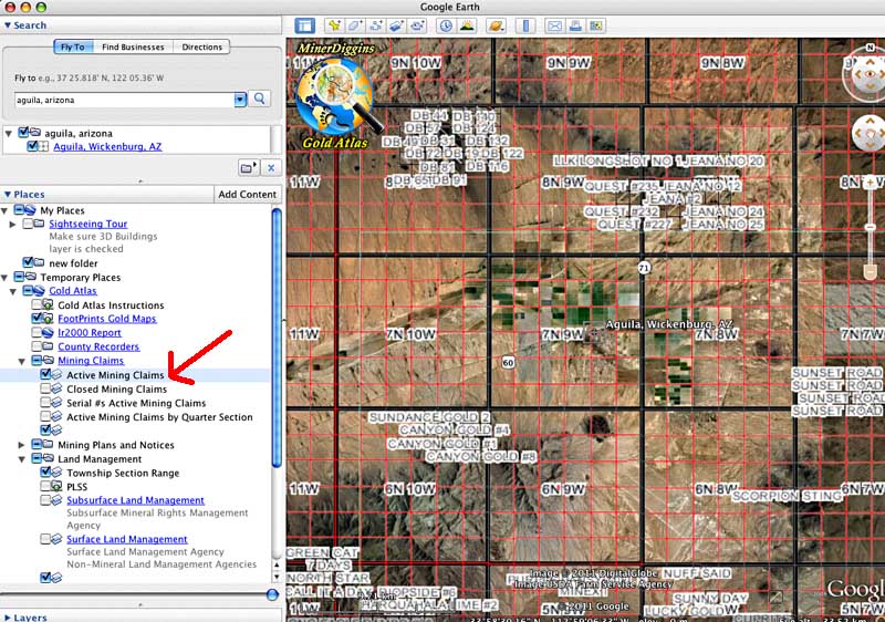
STEP
4:
Add the Mining Claims Layer. Open the folder named "Mining Claims".
Check the box labeled "Active Mining Claims". This will turn on the
BLM layer showing mining claims located in each quarter section. Zoom in and
out, and around to see what's out there.
STEP
5: ZOOM
in to your area of interest. I suggest you keep it limited to a few sections
as seen below.
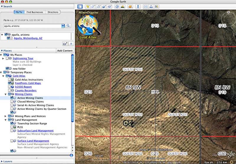
STEP
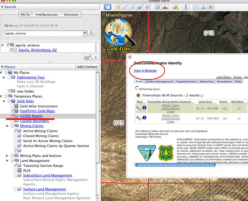
6: Call
up the LR2000 Database. Check the box titled "lr2000". A pop-up window
will appear in the center of the screen. Click on the "View in Browser".
This will open the window in your default Browser.
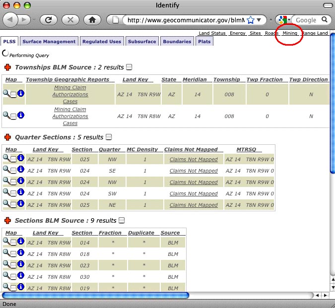
STEP
7: A
Pop-Up
window will appear in your browser. This will show reports for the Townships
you have chosen. To Look at the Mining Claims you need to click the "Mining"
tab in the upper right hand corner of the screen.
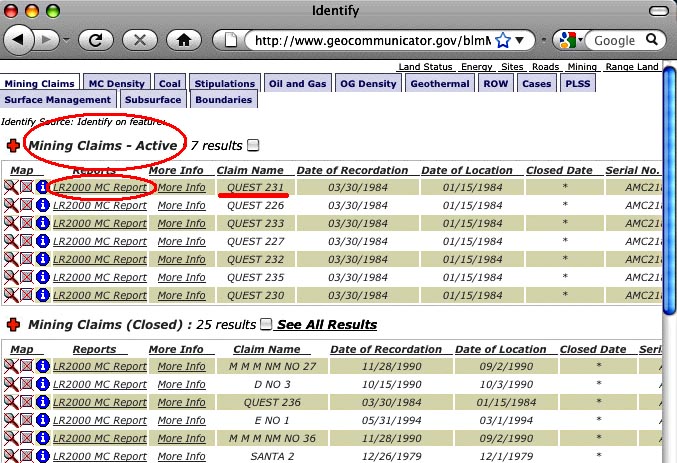
STEP
8: The
window will display several lists of data. Choose the "Mining Claims -
Active" list. Select the name of the claim that you want to research from
the "Claim Name" column. I have selected QUEST 231. DoubleClick on
the "LR2000 MC Report" link for that claim and the LR2000 will display
the Serial Register Report for your claim.
 .
.
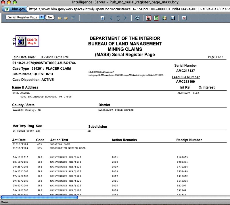
STEP
9: Your
report will look like this. You can save it as PDF, xls using their toolbar.
Caution: this window will only display Page 1 of the report. To read the full
report you must save it.
STEP
10: Finish
your research and Turn off
the LR2000 layer. If you do not "turn-off" the LR2000 map layer by
unchecking the box, a pop-up window will keep appearing as you surf around the
map
You
now have a listing and reports of all the ACTIVE Claims in your area. What do
you still need to know to prospect or claim the area?
You
need to know if the land is open to prospecting.
Turn
on the Surface and Subsurface Management Layer to give you a broad idea of
who owns the land.
Just
because the land is managed by the BLM or the Forest Service does not mean you
can prospect or make a claim. Some areas are withdrawn from mineral entry and
/or prospecting for various reasons. This information is not available on the
GeoCommunicator. You need to contact the managing agency to find this information.
You
need to know what the ACTUAL boundaries of the claims are.
You
need the County Filing to be able to map this information. The BLM LR2000 does
not record claims at this level. Although it may appear to do this in some areas,
it is coincidental.
There are a few ways to find out the actual claim boundaries.
1.
Go to the actual claim site and look for the physical posts. The claim documents
MAY be posted on the location monument.
2.
Get the Filings from the County Recorder. This will involve searching the Recorders
files and purchasing a copy of the filing from the County. They usually run
about $1 per page.
Click
on the "County Recorder Layer" to open a window that displays MinerDiggins
links to almost all of the County Recorders in the West.
3.
If the area you are looking to prospect has been covered by a MinerDiggins
FootPrint,
the claims are already mapped to the ACTUAL boundaries and county records
are provided for you in the program.
You
need to be aware that the BLM and the County Filing may not reflect all valid
claims to an area. When a claim is staked (on the land) the Claimant has 90
days to file with the County Recorder. There are also recording time delays.
At the BLM a record may take weeks or months to show up on the LR2000. You must
check the land itself for any claims filed but not recorded.
For
all of the information you can get from the LR2000, it still does not tell you
if any Gold has been found in your area in the past. The BLM does not identify
the Commodity that was found on the claim. And just because someone made a claim
in the past does not mean there is gold there. In some areas, unfortunately,
lots of claims are made purely for resale.
Use
the information you can get from the LR2000 as a starting point for your research.
There is lots of other information that can help you look for places to find
Gold. Get as much as you can.
If
your area is covered by a MinerDiggins FootPrint, then the information found
by using the LR2000 is already done. In addition you will find detailed information
about the geology, water flow, road access, historical mines, high resolution
aerial imagery, patents, mining history and of course, fully mapped claims.
This
tutorial is one in a series of tutorials designed by MinerDiggins
to aid the prospector in his search for GOLD. The more
information prospectors have about the area they are prospecting, the better
chance they have to get GOLD. And that's what it's all about.