A Quick Guide to Finding BLM Mining Claims on the GEOCOMMUNICATOR.
By Ruby Miner
The USGS has provided a website called the GeoCommunicator to be a "One-Stop" shop for finding information about land status, mining claims, grazing allotments and much more. The website can be a little difficult to navigate because there is so much information to sift through.
This tutorial provides a few simple steps to follow to find active and closed mining claims in a specific Township, Range and Section. There are many options available for you to try should you desire additional information.
Follow this simple Tutorial - Click by Click - to get right to the data you want.
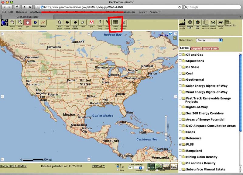
STEP 1: Go to GeoCommunicator on the web. You need to have pop-ups enabled. Have a little patience, ot requires a lot of bandwidth. Here is the link to the viewer.
http://www.geocommunicator.gov/blmMap/Map.jsp?MAP=LAND
This is what the default page looks like.
STEP 2: Zoom to our Place of Interest. You will need the TOWNSHIP and RANGE of the area you want to display.
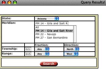
I have chosen to use Township 21N and Range 15W.
You will also need to know your PRIME MERIDIAN: In Arizona it's 14 - Gila and Salt River.
CLICK on the TOWNSHIP button as indicated above. You will get a POP-UP window.
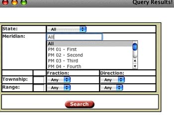
ENTER the information to Zoom to your place of interest
See the Following example for T21N R15W
The field for fraction can almost always be left alone. Very few townships have fractionals. (It would be something like 10 1/2 N)
You will get another POP-UP Window with a Zoom Button and a list of Reports.
DOUBLE CLICK the Zoom Box - (Don't click on the reports yet - Save that for later)
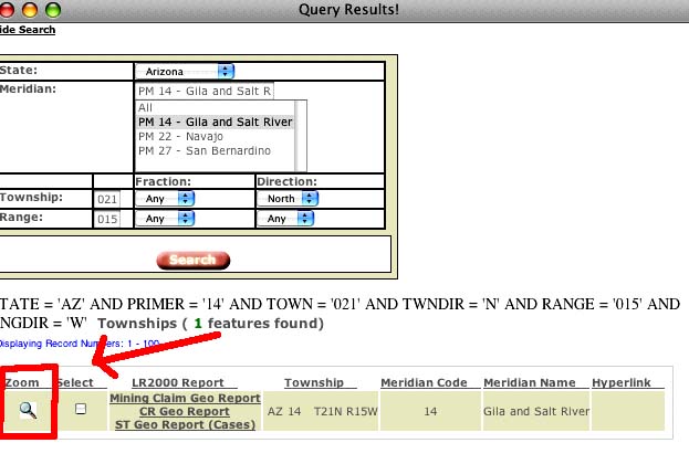
This will ZOOM the main map into the Township and Range you have selected.
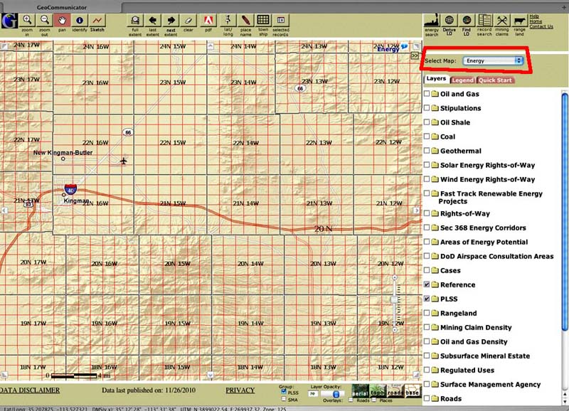
STEP 3: Go to the LAND STATUS Map.
Notice on your screen, the upper right hand corner, the selected map default is ENERGY.
Use the DROPBOX to Select "LAND STATUS"
This will change the view to show you who owns the land.
STEP 4: Basic Navigation
The last step will have zoomed to your general area of interest.
Use the Navigation Tools and to move around and identify specifically the area you want to look at.
Use the Base Map Tools to show Aerials, Topos, Roads and Place Names
Move around the Map to find EXACTLY the area you want to research.
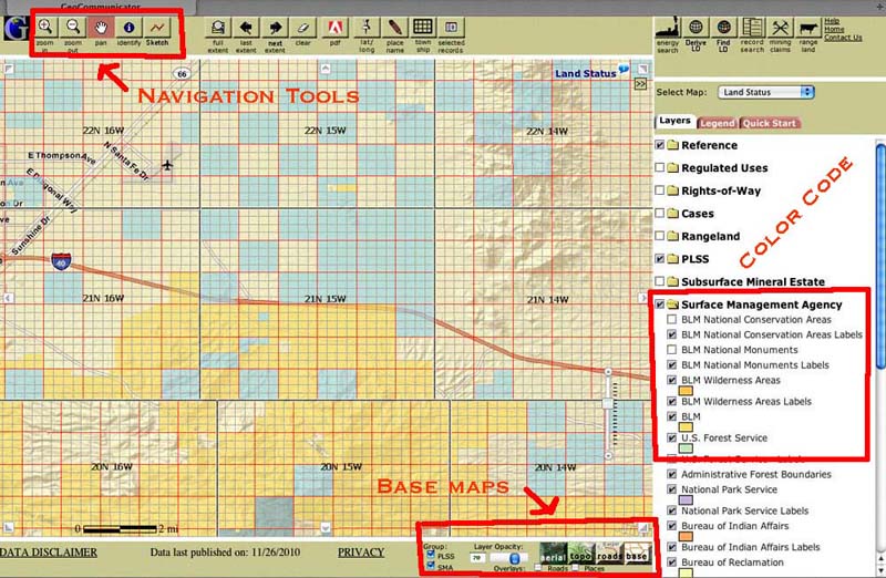
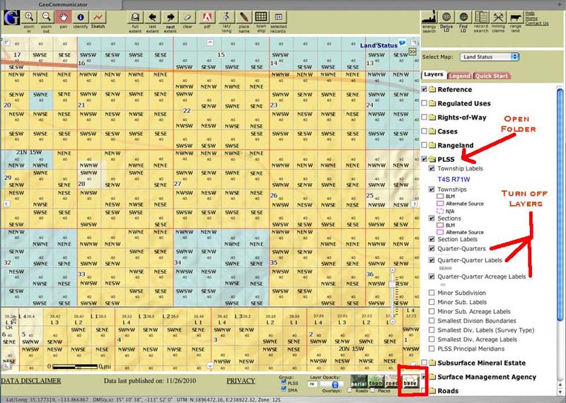
On the next image I have Zoomed In and added a Topo Base map. You can turn any of the map layers on the right, ON or OFF by Checking and Unchecking the box in front of them.
The Key is to KEEP IT SIMPLE. Show only a few layers at a time until you get familiar with the program.
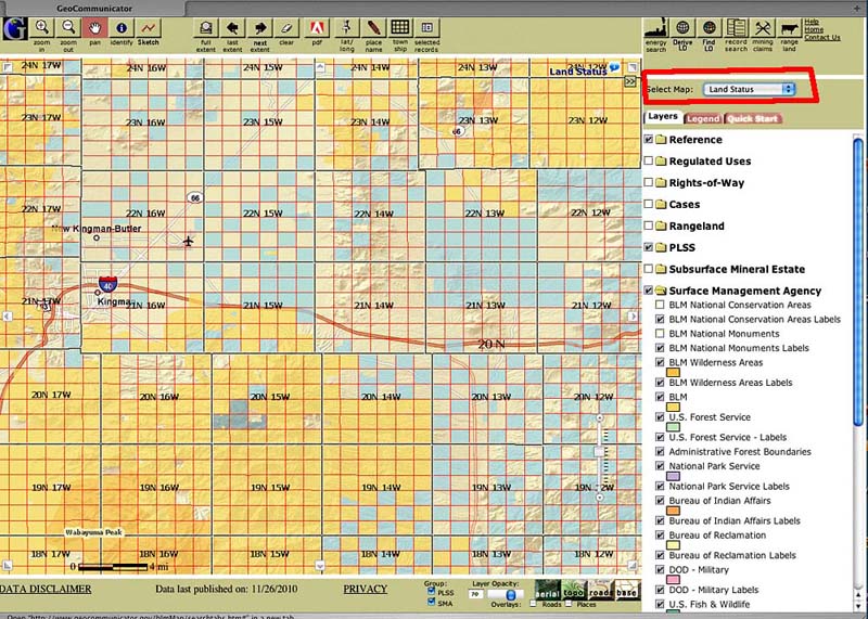
The Layers on the Right under "Surface Management Agency" indicate who manages the public lands. As you can see on this map, most of the land is BLM and State Land.
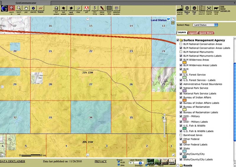
STEP 5: Getting a simple, clear map.
As you zoom in, the default map will begin to clutter up with too much information.
TURN OFF the layers for the PLSS (Public Land Survey System) that relate to Quarter Sections. You can turn them on again later if you need them.
OPEN the PLSS Folder by Clicking on the Folder. UNCHECK the boxes in front of the Quarter Section Layers.
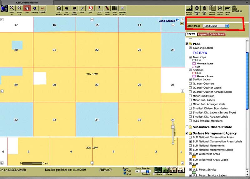
SELECT the BASE map in the bottom right corner
This gives you a Clean Map to help select the exact area you want to prospect.
STEP 6: Display Mining Claims
Now that we know where we want to prospect and who owns the land. Lets find out if there are any Active Mining Claims filed with the BLM.
Go Back to the top right of the page and SELECT the MINING CLAIMS Map using the Dropbox.
This brings up the Mining Claims Map for the area you have selected.
CLICK the checkbox in front of "Active Mining Claims Labels" to Display claim names
CLICK the checkbox in front of "Labels-Serial Numbers" to display the BLM AMC Serial numbers.
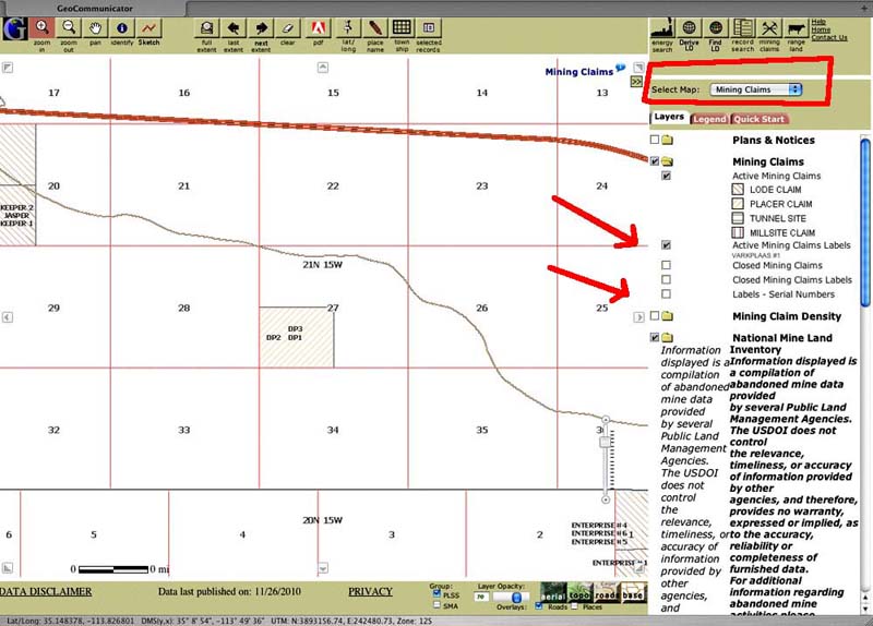
This map shows 3 active claims in Section 27 of Township 21N 15W. The names are DP1, DP2 and DP3.You can tell by the slant on the lines, that these are PLACER claims. These three claims are located somewhere in the Southwest Quarter of Section 27.
You can also display CLOSED Mining Claims and Names if you want by checking those boxes.
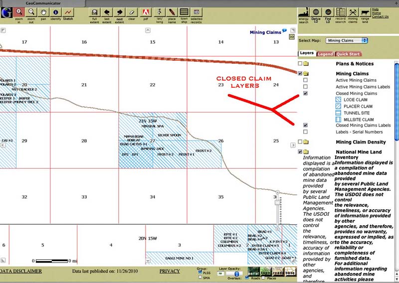
On this example you see many CLOSED claims in Section 27. You can also tell by the crosshatching that there have been LODE and PLACER claims in the Southwest Quarter.
Now we know what ACTIVE and CLOSED Mining Claims the BLM has listed in the Area. What we don't know is exactly where they are. The BLM maps these claims to the nearest Quarter Section. The boundaries you see on the map are not the actual claim boundaries. You need to go to the County Recorder to get the Public Filings for Each Mining Claim.
STEP 7: Getting the BLM LR2000 reports on the Claims.
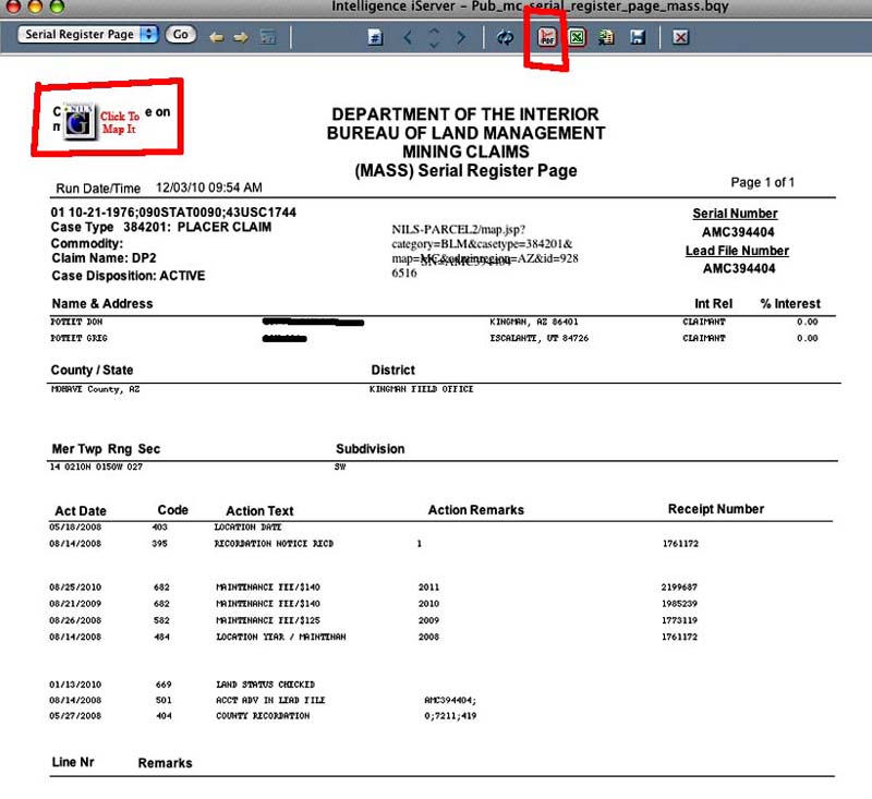
You can access the records from the BLMs claims database, the LR2000, directly from this map. This will give you the Serial Register page which shows the Claims owners, the AMC number, the Claims status and lots of other general information.
To get the LR2000 you need to use the SKETCH tool to draw out the area you want information on.
CLICK on the SKETCH tool.
Draw a box around the area you want information on.
DOUBLE CLICK to complete the box
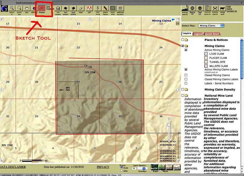
You will get a POP-UP window with links to the appropriate records. It will show all available records for your selected area.
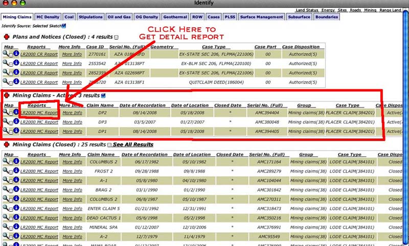
We are interested in Active Mining Claims as highlighted above. You can see the window also shows Plans and Notices and Closed Mining Claims. By keeping your selection area small, you can avoid being overwhelmed by data
STEP 8: Getting Copies of the BLM Records
To Obtain a copy of the BLM Serial Register Page for each of the claims: DOUBLE CLICK the Report Link. You will get another pop up with the report. It may take a while to load. Be Patient.
To Get a copy, use the PDF button. This will download a PDF of the file to your computer.
CAUTION: This window will only display the first page of the report. To view a multi-page report you MUST download it.
CAUTION: Clicking on the Map It button will recenter your main map.
So that's it!
You now have a listing and reports of all the ACTIVE and CLOSED BLM Claims in your area.
Keep in Mind that these are only the BLM LR2000 claims. To find out their actual boundaries you must go to the appropriate County Recorders office.