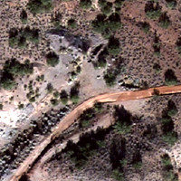
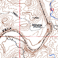
Standard Map Layers
 

Any good map will provide you with some of the same basic information.

Base Layers - A Base Layer is the foundation of the map you are making. Each FootPrint provides three base layers. Any other Map Layer may be displayed over a Base Layer.


Ortho Rectified Aerial Imagery (Ortho)

Aerial Imagery that has been Ortho-Rectified or plotted to geographic coordinates.

Each FootPrint comes with the highest resolution imagery available from public sources for the area.


Shaded Elevation

We have created custom Shaded Elevation maps for each FootPrint using the raw elevation data from the USGS.


Each one is created to clearly show the type of terrain you will encounter in the field.


Topographic Map

Topographic Maps are obtained from the USGS or the USFS if the area contains National Forest Land.

Depending on the area being mapped, some topo maps may show hand written notes of interest specifically to prospectors including prospects, pits, adits etc.


Choose one of these three Base Layers for the foundation of your map. The Base Layer will be seen "underneath" any other layer that is added to your map. This allows you to visualize millions of different map combinations to show you just the information you want.