October 16 , 2010
Greaterville
We have just released our FootPrints map of Greaterville, Arizona. I have to admit this is my favorite one yet. Not only is it great placer ground, but the area has a fascinating history. I have been doing some serious research on the area which I will be publishing here over the next few months.
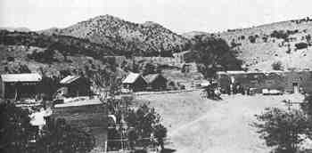
The Greaterville placers were discovered in 1874. They proved to be the largest placers in Southern Arizona. This image of Greaterville, courtesy of the Arizona Historical Society, was probably taken in the late 1870's or early 1880's.
The history of this area has all the elements of a classic western mining town. From the early years when Apaches were still around in Southern Arizona, people have been lying, stealing, cheating, fighting and killing to get a piece of this rich placer ground.
The best placer land in Southern Arizona is now part of the Coronado National Forest, acquired by a lengthy and somewhat controversial land swap in the 1980's. The town of Greaterville itself is in private hands, but almost all of the land in the area is in the public domain.
For now, I am going to link you to the best document for prospectors on the area.
USGS Bulletin # 430-A - Contributions to Economic Geology 1909
Check out the general history of the area and learn about our Greaterville FootPrint.
I'll be back over the next few weeks telling the real story of the Greaterville mining district.
Ruby
Miner Diggins FootPrints - Serious Maps for Serious Prospectors