FootPrint
Details
The
Gold Basin FootPrint provides an incredible amount of information
that you will not find mapped anywhere else.
In addition to the Standard
map layers, we provide custom layers on Mining
Claims, Water
Flow, Geology, Historical placer
workings and even old drywashing sites that can practically
tell you where the gold is to be found.
We
have mapped the Geology of these productive placer areas at
1:48,000 clearly identifying the following;
Gold Bearing Quaternary Gravels
Historical
Placer Workings
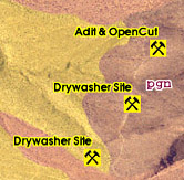
Over
100 pits, adits, old drywasher sites and placers with detailed
descriptions.
We digitize USGS reports and customize the data specifically
for the prospector. We include all source documents in PDF
format in the FootPrint for additional reasearch. In this
FootPrint we include the following detailed reports;
|